Unmanned Air Systems (UAS)
FAA UAS Regulations
Basic Drone Rules - As a Certified Remote Pilot I am allowed to fly under the FAA Small UAS Rule (14 CFR Part 107). A set of specific rules and limitations apply.

- Unmanned aircraft must weigh less than 55 pounds, including payload, at takeoff
- Fly in Class G airspace
- Keep the unmanned aircraft within visual line-of-sight
- Fly at or below 400 feet
- Fly during daylight or civil twilight
- Fly at or under 100 mph
- Yield right of way to manned aircraft
- Do not fly directly over people
- Do not fly from a moving vehicle, unless in a sparsely populated area
Different Rule Application
Commercial vs Recreational
Drone rules split into two tracks: recreational and commercial. Flying for fun is relatively simple. Register the aircraft and stay out of controlled airspace. Flying for pay is not. Using an unmanned aircraft system (UAS) for any paid work requires a knowledge test, a background check, and an FAA Remote Pilot Certificate.
I hold that certificate. I passed the FAA Part 107 Airman Knowledge Test and a criminal background check, which means I can legally fly for hire. That includes stock aerial imagery and video, film and production work, wedding coverage, and real estate photos and video.
Explantion of each Class
Airspace Definitions
Controlled airspace is divided into classes. For drone work, the class determines whether you can fly and whether you need air traffic control authorization first.
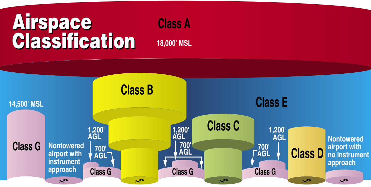
- Class A - Starts at 18,000 feet mean sea level (MSL) and extends upward, including the airspace over waters within 12 nautical miles of the coast of the 48 contiguous states and Alaska. Small drones do not operate here.
- Class B - Surrounds the nation’s busiest airports, from the surface up to 10,000 feet MSL. Each area is drawn individually and usually has a surface area of about 5 miles, plus two or more shelves above it. On a chart, the shape often looks like an upside-down wedding cake. Authorization is required before a drone can enter.
- Class C - Surrounds busy second-tier airports that have a control tower, radar approach control, and enough instrument traffic or passenger volume to qualify. It runs from the surface to 4,000 feet above the airport elevation (shown on charts in MSL). Each area is tailored, and the surface portion is usually a 5-nautical-mile radius. Authorization is required before a drone can enter.
- Class D - Surrounds airports with an operating control tower, from the surface to 2,500 feet above the airport elevation (shown on charts in MSL). The exact shape of each area is tailored to that airport. Authorization is required before a drone can enter, and only while the tower is open.
- Class E - All other controlled airspace. It is not Class A, B, C, or D. It may begin at the surface or at a set altitude and continues up to the controlled airspace above or beside it. This class also includes federal airways and the transition areas that start at 700 or 1,200 feet above ground level (AGL). Over the United States, including waters within 12 nautical miles of the coast of the 48 contiguous states and Alaska, Class E also begins at 14,500 feet MSL and continues up to, but not including, 18,000 feet MSL. Drones need authorization to enter Class E that starts at the surface.
- Class G - Everything that is not Class A, B, C, D, or E. This is uncontrolled airspace. Air traffic control does not manage it, except when a temporary control tower is in place. Most routine drone flights happen here, still subject to altitude, visibility, and other operating rules.